WESTFJORDS, ICELAND 2019
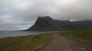
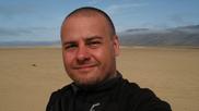
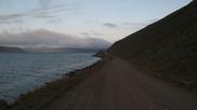
Bjarkalundur Area Hike: This was the first place that we
stopped at on our trip around the Westfjords in Iceland. It is
located just south of Hotel Bjarkalundur. We did a short uphill hike
east of the road to get some fresh air, check out the local sheep and
enjoy the beautiful scenery after driving from the airport.


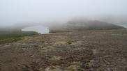
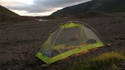
First "Night" Camping: After our overnight flights and drive
up to the Westfjords we decided to relax and camp a bit early and so
we headed for a small mountain lake just west of Porskafjordur.
Parking at the start of an old gravel road we walked east along the
gravel road until we saw the lake. Finding a great spot on the south
end on a pebble beach we relaxed for a while and then went on a short
hike to explore and enjoy the views around and over Porskafjordur. It
never got dark in the evening or at night, which was a new experience
for us! The lake had a couple of loons which kept us company with
their calls at night. In the morning we woke up to some amazing fog
and after having breakfast we packed up and headed out in search of
our car.


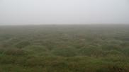


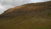
Baejarnesfjall Area Hiking: After finding our car we headed
west along Hwy 60 and stopped a couple of times for some short hikes
along the road to explore a few interesting places - the fog was still
around adn was making everything look that much cooler!


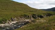
Vatnsfjordur Hike: This was a great ~3h hike along the shore
of Vatnsdalsvatn (Vatnsdals Lake). First we headed along the east
shore and pebble beaches to the Lambagil gorge which took almost an
hour to get to, and shortly after arriving at the gorge the fog begun
to lift and the sun started coming out. After resting at the beach by
the base of the gorge we started heading up the windy trail, gaining
elevation and beautiful views! The trail was then relatively flat,
passing by a shallow lake and ending up the beautiful waterfalls of
Pingmannaa river. There were several interesting arctic flowers that
we saw along this hike.


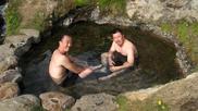
Hellulag Hot Spring: The best way to relax after a long hike
is to jump into a hot spring! This was a great spring, right by the
road but hidden, at the base of a cliff and overlooking the ocean.
Very clear and clean water, perfect temperature and not too busy. We
were there during high tide so with the Atlantic just steps away and
took turns jumping into the icy cold water and getting back into the
spring! The water in the ocean was so cold it was difficult to breath.


Bardastrond Beach Camping: After getting warmed up in the hot
spring for well over an hour we headed west and stopped at a great
beach by a minor road (611) for the night. It was getting foggy and
dark-ish again, so we enjoyed our hot soups and watching the tide
going out. In the morning things looked about the same as they did in
the evening!


Gordar BA 64 Ship: On the way to the red sand beach and bird
cliffs we stopped by an old ship on a beach at the east end of
Patreksfjordur. he ship has been beached here for almost 40 years now
and is slowly rusting away. There was still a lot of low fog around,
cutting off the tops of the mountains.


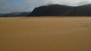
Raudasandur: After some "interesting" windy and foggy roads
we made it down to the red sand beach area. First we stopped by a
little church to the west and then drove east and parked next to the
campground to enjoy this special place. The tide was moving out and
more and more of the sand was appearing. I always enjoy walking on a
beach that doesn't have any signs of human activity, and that was not
hard to find here with the smooth and very clean sand as we walked
west along the beach which went on for many miles. The fog was still
surrounding us and the cliffs to the east and also blowing from the
ocean, which looked amazing.


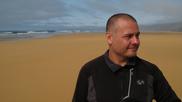


Latrabjarg Cliff: Next we headed to the bird cliffs to check
out some puffins! We drove by the beautiful white sand beaches at
Breidavik and Latravik, with the turquoise coloured Atlantic. The
weather was rather cold and windy here, but wearing all of our layers
we walked along the cliffs to a bit further than most people went.
The cliffs continues for about 15km. After taking in the views we
headed back to where the puffins were hanging out, on the cliffs close
to the parking lot! This is also the west-most point in Europe. We
had a bite to eat and then explored the interesting site at the
Latravik beach with some remains of old houses and a very heavy stone
that someone lifted a long time ago. The guys couldn't do it.


Bruarpotturinn Hot Spring: After our cold adventure with the
puffins we headed north, past the popular Pollurinn hot pool to a more
secluded and natural pool. While there were no people here, the water
in the pool was sadly much too hot to go in unfortunately as too much
of the hot water was being diverted into the pool. After fixing it a
bit (unfortunately it would take many hours to cool...) and getting
our car unstuck, we drove to the Polllurinn pool and squeezed in
between some people. The location of the Bruarpotturin pool is
amazing so it's a place I will for sure go back to when I visit this
region again, hopefully it won't be too hot then!


Beach on Arnarfjordur: After driving well into the "night"
along a really interesting road right by the fjord we ended up on a
great beach just west of the town of Bildudalur. This was a perfect
place for camping, surrounded by beautiful cliffs half hidden by the
fog. Again, things still looked exactly the same when we woke up!


Foss and Reykjafardarlaug Hot Springs: We started our fourth
day by stopping by the tiny "village" (I counted three buildings) of
Foss to explore the foss. Then we headed for the beautiful hot
springs and pool at the end of a little fjord. There is a large hot
pool here and a set of three small natural pools, the top one being
the hottest and deepest while the bottom one the coolest and
shallowest. One usually has to work their way up to the top one,
which is pretty darn hot! Very nice location. We also bumped into
two guys from Poland (who looked like real Vikings!) whom we met at
the first pool that we went to on our second day.


Hiking Above Dynjandi Waterfall: We stopped by several spots
along the way to Dynjandi Waterfall to do some hiking. There were
several nice places to walk around and explore, including a nice
waterfall not far from the road on the plain above Dynjandi. It was
the only place where I noticed some very interesting red arctic
plants. The rich green moss around the waterfall really stood out in
the gray/brown landscape when the sun came out!


Dynjandi Waterfalls: This huge waterfall was an amazing sight
to behold, especially once you get close to it. It's 100m high and
about 60m wide at the bottom, and it makes a lot of noise. On the way
up to it there are several smaller waterfalls with very Icelandic
names! We climbed as high as we could go and enjoyed the views up and
down. There was a Viking cooling off under the waterfall - it must
have been a hot day in the Westfjords by Icelandic standards!


Haukadalur Hike & Camping: We continued north along a
mountain pass with some steep roads, past the town of Pingeyri and
then west to a little bay where we parked by an old French cemetery.
Crossing the road we walked into the valley and kept going along an
overgrown road which turned into a single lane track and then more or
less vanished. We headed down and cut across a stream and then up
along another stream to get into a smaller valley where Andrew and
Alan scouted out a great flat spot for our tents right by the river.
Away from any signs of civilization we enjoyed some hot dogs cooked on
our stove and coffee with hot chocolate. We woke up to a bit of fog
around the mountains and several sheep graving in the area, and slowly
made our way back.


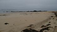
Holt Beach: This was an amazing white sand beach with very
soft sand! We couldn't find the place to get to it at first, parking
too far down the road but it turns out you can just drive on the
little road to the old airport and park right by the pier. We walked
down the beach and enjoyed great views of the fjord. Hiding from the
wind behind a small sand dune we laid down and got warmed up by the
sun while listening to the waves.


Beach Past Sudureyri: Around the corner from the town of
Sudureyri, about 1km down the gravel road, we arrived at a very pretty
black beach surrounded by awesome cliffs. There is an old turf house
that looked like it was restored recently, and a bunch of fish heads
hanging around! We sat around on the rocks of the beach and enjoyed
watching the waves crash as the tide was coming in.


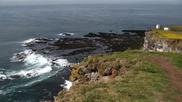
Bolafjall Mountain: We had second thoughts after seeing the
road going up to this place, but upon seeing another little car going
up we pushed on and made it to the very top of the Westfjords, and the
625m cliffs! At 66 degrees and 11 minutes this was the northernmost
point that we would reach on our trip and the northernmost point that
I have ever been to so far, about 35km south of the Arctic Circle!
Looking to the NW would be Greenland, just over 250km away, and to the
north the uninhabited Hornstrandir region of Iceland. There is an old
NATO radar station at this location, and a short string in one spot to
prevent you from going over the cliffs!


Skalavik Beach Camping: Surviving our trip down from
Bolofjall Mountain we headed west along a beautiful road to the bay at
the end of Road 630. The winds were VERY strong here and after
exploring the black beach we hid behind the car while making our food,
and later Alan and Andrew set up their tent behind the car while I
found a spot just a bit lower somewhat shielded from the winds. The
wind kept blowing all night and managed to invert one of the tent
poles on Alan's tent!


Litlibaer Cafe: We stopped by this turf house cafe by the
side of the road in Skotufjordur. We skipped the coffee as we just
had our own not long ago, but walked around and looked at some of the
ruins of old turf houses and other old buildings. The farmstead here
was originally built in 1875.


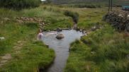
Horgshlidarlaug Hot Pool: This turned out to be one of our
favourite hot pools! Located right by the side of a gravel road, we
had it to ourselves for about two hours! During that time only 2-3
cars drove by and no one stopped by to go in. The guys enjoyed some
beers and me my cider, which was great before our long hike to camp
that followed.


Botnfjall Camping: After warming up at the nearby pool for
almost two hours, we started our hike along the river trying to get to
a lake in the mountains to camp. The hike proved longer than planned,
uphill most of the way. As it was getting late and I was getting
cold, tired and hungry, we decided to camp by the river. From what we
could see it would have been at least another hour to get to the lake,
so I'll have to try next time! The hike was interesting otherwise, as
after climbing by the waterfalls we were in a place that was not often
visited by humans! This was the most isolated camping spot we went to
on our trip, and loved it.


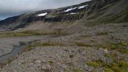
Drangajokull: After a relaxing 30min dip in the
Horgshlidarlaug pool after our hike back from the camping spot, we
drove north to Kaldalon Bay for an amazing adventure by the Dranga
glacier. The gravel road 635 follows the shore and from it we could
see the fjords that we drove around to the left (including Bolafjall
Mountain at the end, which we visited two days ago) and to the right
the uninhabited Hornstrandir region. There are amazing waterfalls
coming down both sides of the valley here before you even set out on
the hike. We took our camping gear and walked towards the glacier for
a while and decided to set up camp behind a little gravel hill to be
shielded from the winds. Leaving our backpacks behind we set out to
hike towards the glacier, crossing several small streams coming from
the waterfalls which were surrounded by beautiful green moss.
Eventually all signs of vegetation ended and we came to a very fast
moving river that comes out from under the glacier. I enjoyed this
view sitting by the river while my friends explored a bit more.
Heading back I took a lower trail which turned out to be much faster
as it's smooth and less rocky, and I came across many blueberries. We
spent the night here and in the morning drove out and then a bit
further north along 635 before turning back and heading south.


Turf House: On the way to the east side of the Westfjords, by
the intersection of 61 and 608, we stopped by this pretty turf house
in the middle of nowhere! On the map it is marked as a shelter, and
it might have been used as that by people walking across this barren
plain as it doesn't look like this would be a good place to live or
farm! It was quite windy, and there are no places to hide from the
winds (or rain and snow!) out here. The structure looks fairly old as
there is old lichen growing on the walls.


Gvendarlaug Hot Pool & Springs: We next stopped at the Hotel
Laugarholl and went to check out their hot pools. For 500 ISK you can
have a nice shower in the very clean facilities and enjoy either the
large swimming pool or the little natural pools just to the side
(where I spent most of my time!). The smaller upper pool is quite hot
while the lower one is just a bit too much on the cool side (and also
very shallow). They are both very pretty though. After spending some
time here we decided it would be a good place to stay for the night as
we saw a large campground with only one car on it and by staying here
we could also enjoy the pools (and a shower) in the morning.


The Drive: After setting up our tents and having a bite to
eat at the Gvendarlaug campsite we went for a drive along the east
side of the Westfjords. While the weather at the campsite was nice,
10min into the drive, around the corner where the road starts going
north by the Greenland Sea, the weather was somewhat harsher! It was
more windy and cold here, very foggy and we could see a lot of rain
falling over the water, making it difficult to see the Northfjords
across. However, the road was absolutely amazing here - in about 1.5h
of driving we saw only two cars and one house! For sure it's a place
I will want to explore more on the next trip, go further north to the
Krossneslaug pool and do some hiking in that region. Just when I
thought I have seen most of Iceland, this little drive made me want to
go back (and made me sad knowing that the next day we'll be driving
back and camping close to the airport). The last pictures is a
sunrise pic on the day we were leaving - we camped by the lighthouse
at Gardskagi, 15min west of the airport.