Cape Breton, Nova Scotia 2025
Indian Point Beach Hike: After two days of driving (1900km)
with my friend Mirela, getting to Nova Scotia and spending the night
just before Cape Breton, we did our first morning hike to a beach
starting at a little cemetery just north of Judique. The trail led to
an old pioneer cemetery with unmarked graves and along beautiful
boardwalks to a pebble beach. It was wonderful to have this long
beach all to ourselves and enjoy our first morning on Cape Breton!


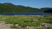
Sutherlands Cove Beach Hike: This hidden beach was high on my
list and I'm glad that we found it. It is near West Mabou and an
unmarked trail off the gravel road (which was a beautiful drive!) near
a house takes you to it. The walk down on a wide grassy path was
easy, being downhill, but less so coming back being uphill all the way
with the temperatures rising high already early in the day. It was
worth it however because the beach is one of the most stunning ones
that I have ever visited; beautiful sand, dunes, grass, roses, clear
waters. We spent about an hour relaxing and sun tanning here.


West Mabou Beach: On the way back from Sutherlands Cove, we
stopped at the West Mabou Beach which is in a Provincial Park. Unlike
the previous unmarked beach, there are parking lots here and it was
quite busy, but most of the people were concentrated at the foot of
the very short path to the beach so it's easy to walk away if you want
a quiet spot. This beach has absolutely amazing sand and also has a
nice lookout from above with picnic tables. It's a perfect beach for
swimming and kids, and close to the main road. We loved walking along
it in the water.


Whale Cove: In Dunvegan we took #219, which follows closer to
the water than the Cabot Trail, and went on the little side road to
the Calvin United Church Whale Cove Cemetery which ends in a little
parking lot with some nice short paths around the point overlooking
the Gulf of St. Lawrence and the beach at Whale Cove. Had a beer here
which we just purchased at Route 19 brewery and rested for a bit.


Petit Etang Beach: We stopped at this beach as it was one of
the camping spots that I had in mind for the first night. The views
here were beautiful and it is located just south of Cape Breton
National Park - the mountains visible from here are in the park. The
beach has a lake on the other side of the sand/rock bar. The waves,
sounds and warmth were amazing, however, since the sun was still a bit
high and no shade available, after our long and hot day, we decided to
drive with the AC on for another ~40km north to Pleasant Bay, which
would give the sun some time to dip lower and we could also enjoy the
amazing afternoon light on some of the best views along the Cabot
Trail.


Cabot Trail and Camping in Pleasant Bay: The views from the
road along this section were stunning, and hard to show with a few
pics so we enjoyed them mostly with our eyes. We stopped at one stop
and explored a little picnic stop. The road has many turns and
impressive gains and drops in elevation! After getting to Pleasant
Bay we found St. Andrew's Church which was our destination for the
night. Near the church overlooking the beach (and the small town to
the left) we set up for the night. Unfortunately the winds were a bit
strong and the fly kept flapping around, some local decided to drive
around after midnight on an ATV and we had a very poor sleep here
after being tired by the sun all day long.


Gampo Abbey: We started our second day very early (since we
got little sleep anyhow!) and headed off along the gravel road north
of Pleasant Bay to explore the grounds of Gampo Abbey, a Buddhist
abbey located on the cliffs of north-western Cape Breton basically at
the end of the road. The monks were still sleeping so we walked and
sat around enjoying the peaceful setting and amazing views in every
direction. After we drove just a bit further north to find the
parking where the trail to Pollett's Cove begins.


The Lone Shieling: Back on the main road we stopped for
coffee at a little motel/restaurant and then did the short hike to
this interesting historical site. This is a Scottish-style sheep
crofters hut (also known as a bothan or shieling). Built in 1942, it
is one of the earliest structures in the park. It was constructed in
the same design or plan as the lone shieling on the Island of Skye in
Scotland and it sure did bring back memories of my trips to the
region!


Campground and South Harbour Beach: We went to secure a
camping spot for the night at the beautiful Hide Away Campground and
then proceeded down the road to find the access to the unmarked South
Harbour Beach. The road was a bit bumpy and we parked a few hundred
meters before the end (near a tiny cemetery across from the parking
spot) and walked the last section. It was very hot so we only stayed
for a few minutes and decided to come back and spend more time here in
the evening.


Dingwall Beach: After eating and cooling off in the shade at
our campsite, we drove to Dingwall from where I sent a postcard to my
little sister in Calgary and then headed off for the nearby Dingwall
Beach. There was a little harbour on the way with ships and a small
lighthouse across the bay which we investigated. The beach itself was
amazing, very long, super fine sand, lake on the other side, calming
waves and we got to see our first jellyfish. There were several dead
ones floating around in the clear water. The view to the West was
onto Cape North, the northernmost point in Cape Breton and Nova
Scotia, making this a very special place (I took a rock to remember it
better). It was super hot so we walked along the beach for a bit and
headed back to our campground.


Sunset at South Harbour Beach: After again cooling off at our
campsite (which has a large skull of some creature, maybe a whale), we
headed back down the road, this time driving all the way around the
large potholes to this amazing hidden beach to enjoy the sunset. It
was a hot day and after splashing around (and not seeing any
jellyfish...) I jumped in and did some swimming here. The water was
fairly cold,but refreshing. We walked along the beach, relaxed and
waited for the sunset.


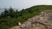
White Point Hike: Our third morning begun with a drive to the
little town of White Point (road sign was missing, so we almost missed
the turn off) and a hike which begins at the end of a very short and
rough gravel road (you can park at the harbour and walk from there).
The trail starts uphill for a while with amazing views to the north,
until you reach the top from which you can see the point. From there
we hard some very strange and loud noises which turned out to be
walrus! They were sitting on rocks in the ocean and at one point
started to fight. The trail is great and gives beautiful views all
around. I went down to the beach separating the end end of the point.
This trail continues south to Burnt Cove along the coast (~1km).


Jack Pine Hike: Next we stopped at the hike which goes to a
"squeaker hole". The trail was very different, going through a pine
forest and had very nice boardwalks. We got to the ocean in ~15min
with some nice view. The waves were not very large but this spot must
be exciting when they are!


Tarbotvale Pool: After a beautiful drive along the East side
of Cape Breton Highlands, we had an hour before checking in to our
place so we stopped to eat and headed for a short drive on a gravel
road to a bridge over a river. It was a beautiful spot in a valley.
On the way to our room at Rumi Guest House, we stopped at Cabotto
Chocolates to get some snacks!


Red Island Trail Hike: After a nice shower and some food
outside, we headed to St. Ann's Church where the Red Island trail
begins. This was a wonderful trail along MacDonald's Big Pond which
eventually takes you to the stony beach from which we enjoyed a
beautiful sunet behind the mountain before heading back as it was
getting darker. There is a bit of a drop off when the trail hits the
beach and rope to help you get back up, but you can walk 10m north in
the forest to gain much easier access. This would be a great camping
spot that is worth exploring more to the north.


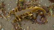
Gooseberry Cove: Waking up early again after an excellent
sleep we drove to the south-east corner of Cape Breton to visit a
place that was high on my list. The weather was clear, sunny and
already warm for most of our drive until we hit the coast, at which
point we entered beautiful fog and cooler temperatures. We parked by
the side of the road and walked ~300m along the gravel road to the
cove. The view was amazing and reminded me of a place I stopped by in
Iceland when it was foggy, although there was more "colour" here since
the beach and rocks in Iceland were all black! We walked along the
beach and played around with the strange things that washed up on the
shore.


Louisbourg Lighthouse: Driving west along the coast, the fog
continued and we ended up at the beautiful lighthouse at the end of
the road just before town. Turns out there is an excellent path along
the shore here from the lighthouse parking lot and we walked a bit
along it and sat on the bench to enjoy the views of the waves crashing
on the rocks. We then went to town and luckily there was no fog there
so we got to see the pretty colourful houses and stopped for the best
fish & chips at the Red Bus food truck behind the General Store. They
were also the cheapest we had on the entire trip (cash only).


Gabarus: What followed Louisbourg was one of the best drives
of my life. We headed back north on #22 and then did a shortcut on a
road from Albert Bridge through Trout Brook to #327. The road is
labeled "Trout Brook" and is right beside a Shell gas station. It's
the most fun and twisty road I have ever driven on, and I don't think
we have seen a single car on it! After a bit of fun (that is,
driving) we arrived at the beautiful little (and very quiet) town of
Gabarus. Here we spent a bit of time watching the waves on the empty
pebble beach and then visited the little lighthouse.


Belfry Beach: Our final destination in Cape Breton, a short
distance to the West from Gabarus, was Belfry Beach. Once again we
were in thick fog which made this beach look very cool! We sat here
for a while and I explored to the East, going to the first point,
beyond which the beach continues. This was a great location with good
camping spots. I took some sand home as a souvenir. After this beach
we headed off of Cape Breton to stay on the south shore of Nova Scotia
and to have a bit shorter drive on the way home. After a fun drive -
especially by the coast - we reached our campsite at Murphy's
Campground near Pleasant Harbour in the evening.


Martinique Beach: We had a good night of sleep at the
campground while it rained a bit overnight. Waking up to another
foggy morning we drove a bit West to this beach, which was shrouded in
mist! The beach is wide, long and shallow, making the waves crash
with a loud noise. We walked along it and sat for a while, listening
to the waves and seeing a few people emerge from or vanish into the
mist once in a while, as if they were ghosts.


Bull Beach: After getting back to our campsite and having a
bit to eat we headed out for our last trip, to Taylor Head Provincial
Park. The objective was to investigate the first beach there and it
proved fruitful. This smaller beach is usually passed on by people
who drive all the way to the end to the larger beach, so we had it all
to ourselves and stayed there sun tanning and walking back and forth
for about 2h until the late afternoon. The clouds, light, colours and
temperature were simply perfect, as well as the sound of the waves.
We had a great shady spot at the very south end of the beach as the
sun was already somewhat low. An amazing way to end our adventure.


